Description
Preliminary hands-on activity
The aim of this experiment is to let the participant observe the differences between fresh and salty frozen water.
The participants fill the two beakers with water, add one and a half teaspoons of salt to one of them and mix until the salt is completely dissolved. Then they apply a label to each beaker and put them in the freezer.
Second lesson
The participants extract the pieces of ices from the beakers by warming a bit them under warm water. So they can observe the difference between salty and fresh frozen water. Then they poor some food colouring on the upper face of both the pieces of ice to observe how it pervades the inner part of the salty one. This happen because the frozen salty water has inside some veins of liquid water with a very high concentration in salt.
The monitoring of glacial seas in the web
Before to analyse real data, the explainer will ask the participants where they think glacial seas are located on Boreal Emisphere. To this task they can use the special map parted in numbered areas (the right areas are 1, 3, 4 and 8. The others are influenced by the Gulf Stream conveying warm waters from the equatorial areas to the north-western coasts of Europe.)
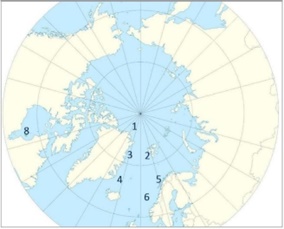
The map of the northern hemisphere on which participants can identify the areas where glacial seas are present.
The web site https://seaice.uni-bremen.de/sea-ice-concentration of the University of Bremen, Germany, provides with data about the concentration of sea ices in Arctic Glacial Sea updated from 2010 until today. Data are from Advanced Microwave Scanning Radiometer 2 device on board of the GCOM-W satellite of Japan Aerospace Exploration (JAXA).
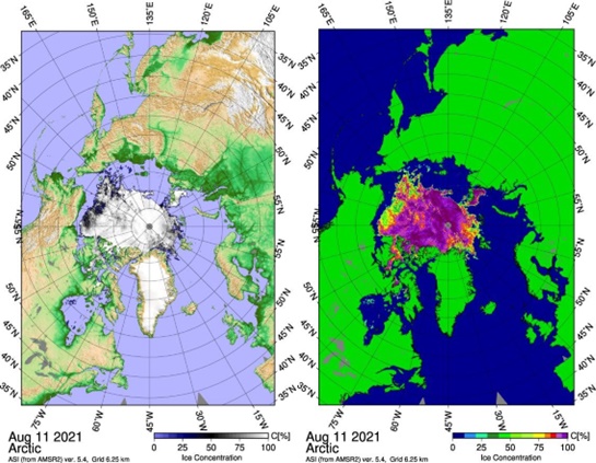
The interactive maps of northern hemisphere from https://seaice.uni-bremen.de/sea-iceconcentration - respectively in real (left) and false (right) colours – where the participants can watch and evaluate the concentration of sea ice over the time.
The concentration of sea ice means the percent of frozen water. So, if concentration is 0%, there is no ice and it means open sea. Around North Pole there is an area not covered by satellite surveys. It appear dark grey and we cannot know its ice concentration.
Participants must indicate on the map where glacial sea ice is and how their concentration varies seasonally and over the years.
The web site https://climate.copernicus.eu/sea-ice from the developing Copernicus Imaging Microwave Radiometer (CIMR) that soon will provide with continuous measurements of the concentration of sea ice in the Arctic and Antarctic Oceans.
Participants will also realize how satellites are effective to monitor the remote places where glacial seas are located. Depending on the degree of the involved classes, teachers could discuss with them about electromagnetic spectrum and the different sensor to use to get useful data. This last point is particular important considering the long polar winters and the cloud cover often present in polar latitudes.