Keywords
Orthodromic route; cartographic projections; geographic coordinates.
Educational Purpose:
This scenario is aimed to illustrate to the participants what an orthodromic is and how it is represented on a flat surface as a geographic map. The scenario entails both hands-on experiences and the use of ICT
Previous knowledge of the participants:
Geographic coordinates; angular measures; scale
Tools and materials:
Different type of geographic maps (if possible a planisphere);
A map showing some air routes;
A globe (as big as possible);
A slightly elastic thread;
Computers connected to the Internet.
Proceedings, description:
The scenario open showing to the participants a World map (planisphere) and asking them which one is the shortest aerial path between two different towns located quite far each other (e.g.: The Athens and New York). It is very likely the most of them will indicate the straight line linking the two town on the maps.
Hence, the explainer shows them a map reporting some aerial routes around the World so they can realize these routes are represented on the maps as curves rather than straight lines (many of such kinds of imagines are available on the web).
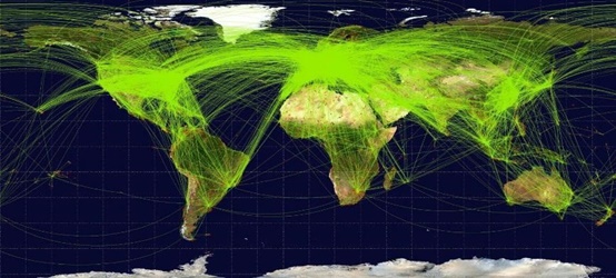
A World map showing several aerial routes. As you can see, all these routes are curves rather than straight lines
Probably many of the participants could be surprised by this fact, and could even think these routes are just a waste of time and fuel.
So the explainer will show a globe and invite the participants to indicate what’s the shortest route linking two different points located very far each other but about at the same latitude. Probably also in this case they will indicate the rout running along the parallel of latitude of both the points. The explainer will provide with the elastic wire to one of them and will invite him to link with the two point with it. The wire in tension will dispose spontaneously along a different path from the one indicated by the participants and analogous to the ones showed on the map of the aerial routes.
If the difference in latitude between the two points is maximum (180°), the corresponding orthodromic route even passes through one of the two terrestrial geographic poles.
On the other hand, in the extreme case of two points located at the antipodes, if we consider the Earth as a perfect sphere, the corresponding orthodromic routes would be infinite and would reach the maximum length (180 ° = 20,000 km) and any arc of a great circle on the earth's surface could work.
To determine the orthodromic routes on the earth's surface in a quantitative way (angles to the center; distances in kilometers, etc.), the web page http://www.spigolo.altervista.org/ortho/index.html offers a simple interactive application to be used and of great effectiveness and graphic clarity.
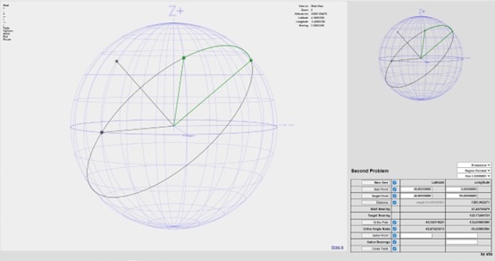
An orthodromic route as represented on the interactive globe of http://www.spigolo.altervista.org/ortho/index.html. As can be seen, the route is an arc of the great circle crossing two choosen points.
Further effective observations could be made using Google Earth Pro. In particular, the "Ruler" tool from the "Tools" menu allows you to trace on the Earth's surface the lines corresponding to the orthodromic paths that connect different points. When the reference grid for latitude and longitude is active, it can be clearly observed how the latitude of the route that connects two municipalities located at the same latitude changes progressively.
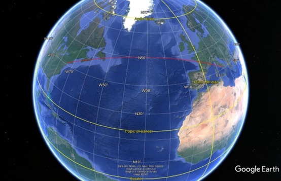
The latitude of the route (red curve) that connects New York to Naples is variable although that of the two cities is the same.