Description
The sphericity of the Earth was known to the ancients, certainly to Pythagoras and Aristotle.
The Alexandrian scientist Eratosthenes (about 250 BC) even measured its radius. At that
time it was believed that Alexandria and Siene (today Aswan) were on the same meridian (today we know that Aswan is a little further east of Alexandria). Eratosthenes observed that in Siene on June 26, at noon, the Sun was at its zenith, while at the same time in Alexandria the rays of the Sun formed an angle of 7 ° 12 'with the perpendicular. But this is also the angle in the center of the Earth that subtends the meridian arc that unites the two cities. And the distance between the two cities was known. By definition, in a circumference, the ratio between the arc and the angle (expressed in radians) is equal to the radius. Thanks to these considerations Eratosthenes was able to estimate the length of the earth's radius, with an error of only 2% compared to current estimates. Subsequently another Greek scholar, Posidonius, estimated the terrestrial radius - obtaining a lower value - by measuring the maximum height on the horizon of the star Canopus from two locations at different latitudes. These measurements were then taken up by the Roman Strabo. The considerations and calculations shown by Christopher Columbus to Queen Isabella were based on the values measured by the ancients (in particular also by Ptolemy) to support the thesis of the possibility of reaching the Indies by traveling west. Fortunately, the estimates used by Columbus were at fault! The experts called by King Frederick, who had made the calculations based on the value of the radius determined by Eratosthenes, closer to the truth, had "rejected" Columbus's proposal, considering it an impossible mission!
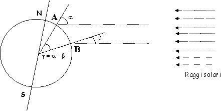
The scenario begins by analyzing the measurement method. The figure shows the meridian passing through the two cities A and B having the same longitude. At the same instant (in the figure the true local noon is represented) the solar rays, which arrive parallel to the Earth, form different angles (alpha and beta) with the perpendiculars in A and B.
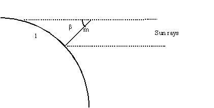
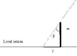
In each of the two cities, known the length m of each gnomon, by measuring the length l of its shadow, we can determine the angle of incidence of the sun's rays - equal to arctg (m/l) (see figure).
The information is exchanged between the two groups of participants and from the difference between alpha and beta we can determine the angle in the center gamma.
The angle in the centre gamma allows us to derive the radius of the Earth from the proportion:
AB: circumference = gamma : 2Pi (6,28).
The distance AB is that between the two cities and can be obtained from tables in literature, measured on the map with the ruler or, better, determined on Google Earth PRO by reporting two "Placemarks" with latitudes corresponding to those of the two measurement sites but which have the same longitude. The distance can then be measured with great precision using the “Line” option of the “Ruler” function from the “Tools” menu.
The difference between the two latitude values will give us the orthodromic distance AB, and therefore angular gamma, necessary to determine the length of the entire circumference of the earth and therefore the corresponding radius.
Distance between the two measurement sites
For example, Italy is very large in latitude but less so in longitude, therefore two schools located anywhere in that same country could be fine as long as they are at least two hundred kilometers away from each other in a north-south direction
Usually it is quite difficult find two carry out the measure in two place laying on the same meridian. For instance, if one class is in Naples (14° 15’ E) and the other in Florence (11° 15’ E), the difference in longitude is 3° 1’
To get around the problem we can determine the right length of the shadows of the gnomons although the two sites are located at slightly different longitudes, is to trace on the floor the path taken by the tip of the shadow during an interval time of about an hour close to astronomical noon. This path will take the form of a curve with a different shape in relation to the period of the year in which the measurement is made. In any case, the length of the shadow with the Sun at the zenith will correspond to the vertex of the traced curve.