Hosted by OSOS , contributed by nunogomes.pt on 4 July 2018
In this activity, you will learn that people living in different parts of our planet see distinct constellations in the night sky. You will also infer what is the shape of the Earth by observing a few constellations and by sharing data with other colleagues living in different latitudes and longitudes.
Involvement of communities during the activity
You will involve your family, your friends, and your local community during the different phases of the activity, by carrying out interviews, retrieving data, providing important information, and sharing results.
Topics
Science; Astronomy; Physics; Culture.
Learning objectives
The main learning objectives addressed in this project are:
- To realise that for a given moment, according to their geographical position, people observe different constellations, or the same constellations but in different positions in the sky;
- To infer the shape of the Earth by observing some constellation and compare data with observations performed in other parts of the planet;
- You will learn or improve your collaboration skills, by working with other students;
- You will apply the steps of the scientific method, and you will have the opportunity to become aware of its importance for the understanding of natural phenomena;
- You will learn how to handle data and the importance of following the necessary steps for data acquisition;
- You will learn how to validate results, to discuss them with peers, to present findings, and to listen to other's ideas;
- You will explore the surrounding environment, and will find more about our communities’ knowledge and beliefs;
- You will learn how to present your own ideas, while engaging the local community in dissemination and awareness events.
Motivation
In a time where there is a big debate in the Internet about the true shape of the Earth, where many people call into question the veracity of photos, videos and data shared by renowned space research institutes, the key motivation for this activity is to give students the opportunity to find a way to infer the shape of the Earth by pure observation of natural phenomena and reasoning, following similar steps of great scientists and thinkers of humanking, such as Erathostenes.
Author
Nuno Gomes
nuno.gomes@nuclio.pt
NUCLIO, Portugal
May 2018
Feel
Orientation - think about what you observe
In a time where there is a big debate in the Internet about the true shape of the Earth, where many people call into question the veracity of photos, videos and data shared by renowned space research institutes, you will have the opportunity to find a way to infer the shape of the Earth by pure observation of natural phenomena and reasoning, following similar steps of great scientists and thinkers of humanking, such as Erathostenes.
You will start by observing some phonemena (change of the position of the constellations in different days, different positions of the constellations when varying the latitude, constellations observable only withing a latitude range), and think about what might be the reasons behing that.
The movement of the constellations at different times of the year
You already know that different constellations are visible in the night sky at different times of the year. This is particular noticeable for constellations close to the horizon.
Question 1
People live at different latitudes. How do you think they see the constellations lying close to the horizon? Do you think those constellations look like the same to everybody?
The following images (figures 1 to 4) illustrate the night sky at Porto (a city in Portugal, in the Northern Hemisphere) and at Cape Town (a city in South Africa, in the Southern Hemisphere) in February and August at 23h00 Coordinated Universal Time (UTC), when facing the South-West direction.
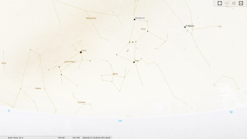
Figure 1: typical night sky at Porto (Portugal, Northern Hemisphere) in February 17th (Winter) at 23h00 UTC, when facing SW.
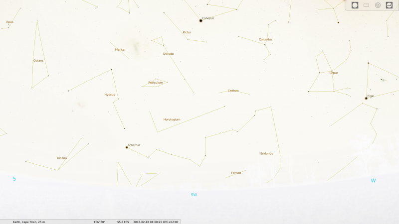
Figure 2: typical night sky at Cape Town (South Africa, Southern Hemisphere) in February 18th (Summer) at 01h00 UTC, when facing SW.
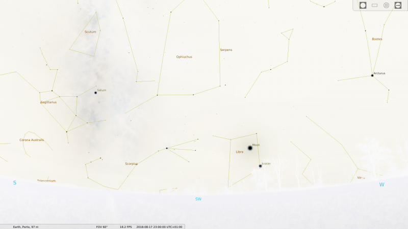
Figure 3: typical night sky at Porto (Northern Hemisphere) in August 17th (Summer) at 23h00 UTC, when facing SW.
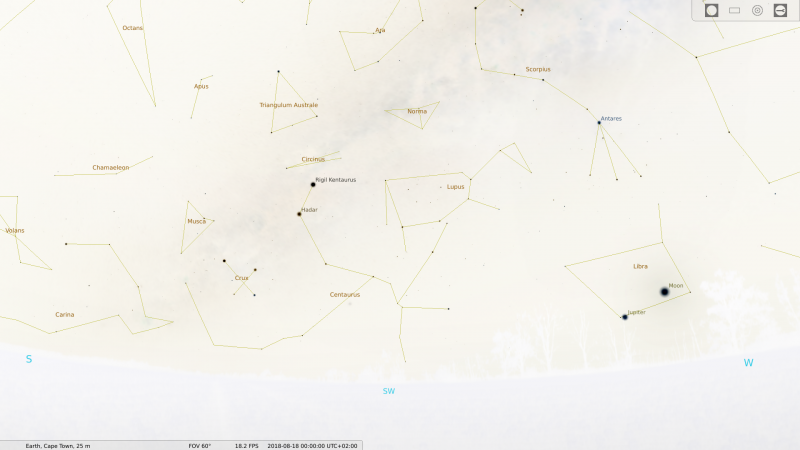
Figure 4: typical night sky at Cape Town (Southern Hemisphere) in August 17th (Winter) at 01h00 UTC, when facing SW.
Question 2
In Figures 1 and 2, and then in Figures 3 and 4, we wanted to show you the night sky in Porto and Cape Town approximately at the same moment. Why do you think the times are not the same? You can use the World Time Buddy tool to check your conclusions.
Before start digging deeper into the project, let us check out the following video to recall what a constellation is.
Let us focus for a moment on the shape of the Earth.
There is currently a big debate among several Internet communities about the true shape of our planet. Some defend that the Earth is flat, while others advocate for its spherical shape. There is currently an interesting article in Wikipedia about the topic, where you can get some information about modern flat Earth societies and their ideas.
Mike Hughes even built a rocket and flew it to check by himself what is the true shape of the Earth:
Eratosthenes proved that the Earth has a spherical shape more than 2000 years ago. Watch the following video, where Carl Sagan explains the reasoning of Eratosthenes.
In the course of History, several arguments have been presented to prove the sphericity of our planet. However, as you could verify in some of the previous links, many people still believe today that our planet is flat. Is it possible that these people are correct?
In order to find it out, let's imagine that our planet has the shapes defended by the two models, i.e., spherical and flat. Suppose you are at some point on the surface of the Earth - make a sketch on your notebook to help you to visualise the situation (ask your teacher or a colleague for help, in case you need it). Identify the plane of the horizon for each model (spherical and flat).
Question 3
How would you see the stars in each case? Are all constellations available to the observer in both models?
Question 4
Can a flat-bent Earth (like a bent sheet of paper) solve the problems you have identified so far? Briefly justify your answer.
We will now do some research in the local community, to understand what is the idea people that surrounds you have about the shape of our planet.
Question 5
What shape people surrounding you think our planet has? Try to find it out by asking that question to:
- The members of your family;
- Your neighbours;
- Your colleagues.
If you have the chance, ask the very same question to:
- The president of your parish;
- Your mayor;
- The spiritual/religious leader of the place where you live.
Imagine
Conceptualisation - visualise change
In this phase you are going to create your hypotheses about what might be the reasons behind the phenomena you are observing. We will propose you a simple experiment to test your hypotheses, but you can come up with a different one.
For the next task, you will have to identify two constellations and start observing them at 22h00 UTC around the first of October (settle the exact day with your teacher). Firstly, if you leave in the Northern Hemisphere, localise the Cassiopeia constellation, and choose another constellation relatively close to the horizon facing approximately South; if you leave in the Southern Hemisphere, find the Eridanus constellation, and then choose one constellation relatively close to the horizon facing approximately North.
Here are some examples of constellations you can pick, in case you live in the:
- Northern Hemisphere: Ursa Major, Perseus, Piscis, Andromeda, Pegasus, Aquarius, Capricornus, Sagittarius, Ophiuchus, Bootes (pick one).
- Southern Hemisphere: Triangulum Australe, Sagittarius, Pegasus, Andromeda, Aquila, Aries (pick one).
Question 6
How do you think people living at different latitudes would see those particular constellations at that time and date if the Earth was round or if it was flat? Would the visualisation of the constellation change? If yes, how? If not, why not?
Question 7
How do you think people living at different longitudes would see those particular constellation at that time and date if the Earth was round or if it was flat? Would the visualisation of the constellation change? If yes, how? If not, why not?
Briefly discuss these questions with your colleagues and teacher, and write down your expectations.
According to your expectations, create one or more hypotheses to be tested with an experiment or by observation. Can you think of a way to find the true shape of the Earth by observing the aforementioned constellations and comparing your observations with the ones made by colleagues living in other parts of the planet?
My Hypotheses
Use your text editor to type your hypotheses (one or more).
After building your hypotheses, proceed to the Create phase, where you will perform real research that will allow you to check them.
Create
Investigation - make the change happen
During this phase, you will implement your experiment and collect the necessary data to create a clear, practical and applicable solution for the problem you have at hands. In collaboration with colleagues from your school and schools from other parts of the planet, you will analyse the data and try to find a common understanding about the true shape of the Earth.
We are going to propose an experiment using the constellations referred in the Imagine phase. However, you can come up with your own experiment to test your hypotheses.
This is a crucial part of the research process: as a scientist, you are going to perform observations of the sky and record them both in your notebook and in an online platform. The activity will take some time to be fully completed, but each time you will not need more than five minutes to fulfil the appropriate task.
Find a nice place to observe the night sky close to the place where you live. It can be your home, a nearby garden, your schoolyard, or another place free of light pollution and obstacles that block the horizon. Ask your parents and/or teacher to help you on this task.
Go to that place at around 22h00 UTC, and identify the four cardinal directions: north (N), east (E), south (S) and west (W).
Now search for the constellations identified in the Imagine phase. If you are having difficulties identifying the constellations, use any free Astronomy software, an online planetarium, a phanisphere or a star chart to help you in that task. Stellarium is a good free planetarium you can install in your computer. The In-The-Sky.org website is also a good alternative. In both you can indicate where you live, the local time and date, and the software will show you how the sky looks like.
In case you decide to use any of the aforementioned planetariums, do not forget to turn on the lines and names of the constellations. Then, find the constellations within the software and fetch them on the real sky. Note that the constellations do not need to be fully visible. It is fine if you can see only a portion of them in the sky, provided you can undoubtedly identify it and find the brightest star belonging to that constellation. For the latter, use the aforementioned planetariums to help you finding them. For instance, Shedar (α Cas) is the brightest star of Cassiopeia, and that for Eridanus is Achernar (α Eri).
After identifying your constellations on the sky, draw them in your notebook, noting down your latitude, the coordinated universal time and date of your observation, the angular distance between the brightest star and the horizon, and the orientation of the constellation relative to the horizon. Try to be as accurate as possible!
In order to determine the distance between the constellation and the horizon, draw the horizon line in your notebook, pick the brightest star of that constellation and estimate the angular distance between it and the horizon using your hands while stretching your arm (see the following figure for help).
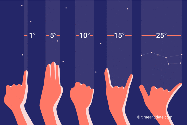 Figure 5: a handy way of measuring angular distances in the sky. Find out more at www.timeanddate.com/astronomy/measuring-the-sky-by-hand.html.
You can also build your own astrolabe and use it to perform more accurate measurements!
After that, visit the Globallab platform, search for your constellations and select the images that best match your observations (in terms of altitude of the brightest star and orientation of the constellation), filling in all the requested data.
Try to observe your chosen constellation at the same time every day but, most importantly, always write down the UTC time and date of your observation! Repeat the exercise for a couple of weeks, drawing it at least three times every week.
Now, in Globallab, have a look at the data obtained by colleagues of yours living in other places of the Earth. Compare the observations at different latitudes and longitudes, but done at the same time and date (the time does not need to be exact, approximate is enough).
Question 8
What do you find? Do your constellations look the same everywhere? Are they visible everywhere? How do you explain what you observe?