Hosted by OSOS , contributed by boutzikas on 11 January 2024
The RURAL (feRes gymnasiUm towaRds digitAL innovation) project, funded by the LfE, improved students' digital skills. Using Geographic Information Systems (GIS) and geospatial data management, the project introduces students to the use of modern digital technologies to present and analyze this data.
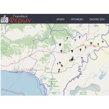
The main objectives (axes) of the project are a) It enables students to collect and input their own data to create a digital map This project uses an open source GIS software (QGIS) and the final product is in the form of a web interactive map (under the school’s webpage) αnd is easily accessible to all users. In this axis the digital map of the churches of the Municipal Unit of Feres was implemented giving information such the name, the type, the village location and photo of each church.
Additionally a linked file was added in some churches in order to present information about them, b) It was used a cloud open GIS data as well as web-based GIS software, the climateEngine app, for the study of the natural environment and climate impact in the area of the Municipal Unit of Feres (soil temperature, drought index, rainfall, greenness, fires, etc.). These data are presented in the form of thematic maps and diagrams.
George Falalakis
Gymnasio Feron
mail@gym-feron.evr.sch.gr
Feel
Guidelines
In this stage, "feel' students visit the churches throughout the Feres area in Evros, Greece
Please provide more info and photos !
Description
What a great time we had !
Imagine
Guidelines
Please add any information of the synergies you have developed
Description
This is the plan we made
Create
Guidelines
Please describe any activities
Description
We have organised an open day at school for the local community